Mangurstadh (Magnus's Steading)
Documentation of an exhibition at An Lanntair Arts Centre, Stornoway, Isle of Lewis in 2012
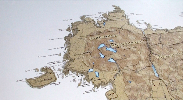
Mangurstadh Map
A handmade paper map by Elsie Mitchell
Map of Mangurstadh crofting township and common grazings. Pencil drawing, water-colour and handmade plant fibre paper collage. The paper was made from common plants growing on the crofts and common grazings - Marram Grass, Potatoes, purple Moor Grass. Based on an OS Map surveyed in the 1840's and a historic map from the late 1800's detailing the common grazings village boundaries in Uig. The area defined in plant fibre paper marks the boundary of Mangurstadh Common Grazings. The colours and textures of the plant fibre are used to define contemporary habitat definitions eg. coastal/ serpentine heath, machair, moorland. The place names are as given on the 1840's OS map. Many are derived from old norse and reveal that the land has been farmed and grazed from prehistoric times.
Please see documentation of the related video installations which complimented the map in the Mangurstadh Exhibition at An Lanntair.
Documentation of an exhibition at An Lanntair Arts Centre, Stornoway, Isle of Lewis in 2012
Mangurstadh Map
A handmade paper map by Elsie Mitchell
Map of Mangurstadh crofting township and common grazings. Pencil drawing, water-colour and handmade plant fibre paper collage. The paper was made from common plants growing on the crofts and common grazings - Marram Grass, Potatoes, purple Moor Grass. Based on an OS Map surveyed in the 1840's and a historic map from the late 1800's detailing the common grazings village boundaries in Uig. The area defined in plant fibre paper marks the boundary of Mangurstadh Common Grazings. The colours and textures of the plant fibre are used to define contemporary habitat definitions eg. coastal/ serpentine heath, machair, moorland. The place names are as given on the 1840's OS map. Many are derived from old norse and reveal that the land has been farmed and grazed from prehistoric times.
Please see documentation of the related video installations which complimented the map in the Mangurstadh Exhibition at An Lanntair.